Cathy Dobson
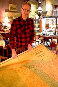
Over more than 20 years of purchasing items for Grace Brothers Antiques, co-owner Steve Chitovas has come across just one original map of historical Sarnia.
Luckily, he had the winning bid.
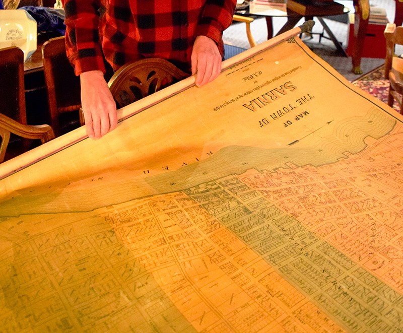
Chitovas bought the 1893 map at auction in Milton, Ont. in 2001 after noticing it advertised in an auction newspaper. When he took delivery, Chitovas was fascinated as he unrolled the large, yellowed map of the prosperous community.
Every building within the town’s boundaries was depicted, from Exmouth Street to the north, train station to the south, East Street to the east and St. Clair River to the west.
Chitovas asked local photographer Paul Sorensen to take a digital image so the map could be downsized by a few feet and reproduced. But they weren’t satisfied with the result.
“So I put in on the back burner,” said Chitovas.
It wasn’t until last spring when he showed it to history buff Randy Evans, that he decided to try again.
“Every time I look at it, I see something new,” said Chitovas. “You can pick out the street names and see what has changed. If you’re from Sarnia, you can look for buildings you know.
“Randy thought the technology had improved enough that a good photograph was possible and he encouraged me to pursue it.”
This time, Sorensen was successful and 44 inch X 33 inch prints were made of the 125-year-old map. Though still large, it’s several feet smaller than the original, which Chitovas isn’t selling.
Copies of the map are on display (selling for $195 each) at Grace Brothers.
“People like to come in and find their house or find some of the features on the map,” said Chitovas.
Features include the streetcar line shown leaving the train station at the end of Palmerston, making its way down Russell Street to Ontario, along Wellington and onto Front.
One customer noticed the map shows a convent on London Road where an apartment building stands today, and told Chitovas he found the convent’s foundation.
Many homes and businesses of early Sarnia are shown with the owners’ names or something indicating what they were used for. For instance, there’s a brewery by the river, likely the Lambton Brewing Co. that opened in 1891.
Several cemeteries have since been moved, along with other one-time landmarks like the O’Gorman boathouse and bath on the riverfront.
The map incorporates the surveys of early Sarnia landowners including Vidal, Maxwell, Copland, Proctor, Francis and Byrnes. It’s dated Jan. 1, 1893 and includes the railway tunnel, an engineering marvel freshly dug under the St. Clair River in 1890.
“What I’d like to know is where it hung,” said Chitovas. Odds are it belonged to a Sarnia business but he has no idea who put it up for auction or possessed it over the past century.
The only hint is a few words and dates scribbled in pencil in the bottom left corner that read: “College 1901 Oct 5. College 1902 Sept. 9. College 1903 Sept. 30.”
Several of the prints have sold to local history lovers and one went to a Calgary couple, originally from Sarnia.
“The price is based on printing costs and the cost of similar sized art,” said Chitovas. It’s not a limited edition print but it’s a rare find.
During the month of December, Grace Brothers Antiques will donate $25 from every map sale to the Sarnia Historical Society.